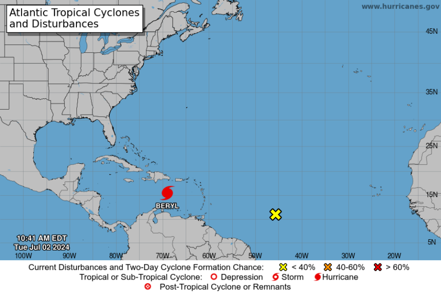
.BERYL CONTINUES MOVING QUICKLY WEST-NORTHWESTWARD ACROSS THE
CENTRAL CARIBBEAN SEA...
...EXPECTED TO BRING LIFE-THREATENING WINDS AND STORM SURGE TO
JAMAICA ON WEDNESDAY...SUMMARY OF 1100 AM AST...1500 UTC...INFORMATION
-----------------------------------------------
LOCATION...15.3N 68.9W
ABOUT 235 MI...375 KM SE OF ISLA BEATA DOMINICAN REPUBLIC
ABOUT 555 MI...895 KM ESE OF KINGSTON JAMAICA
MAXIMUM SUSTAINED WINDS...160 MPH...260 KM/H
PRESENT MOVEMENT...WNW OR 290 DEGREES AT 22 MPH...35 KM/H
MINIMUM CENTRAL PRESSURE...938 MB...27.70 INCHES


WATCHES AND WARNINGS
--------------------
CHANGES WITH THIS ADVISORY:

A Hurricane Watch is now in effect for the south coast of Haiti
from the border with the Dominican Republic to Anse d'Hainault.

SUMMARY OF WATCHES AND WARNINGS IN EFFECT:

A Hurricane Warning is in effect for...
* Jamaica

A Hurricane Watch is in effect for...
* South coast of Haiti from the border with the Dominican
Republic to Anse d'Hainault
* Grand Cayman
* Little Cayman and Cayman Brac

A Tropical Storm Warning is in effect for...
* South coast of Dominican Republic from Punta Palenque westward
to the border with Haiti
* South coast of Haiti from the border with the Dominican
Republic to Anse d'Hainault

A Hurricane Warning means that hurricane conditions are expected
somewhere within the warning area.  Preparations to protect life
and property should be rushed to completion.

A Tropical Storm Warning means that tropical storm conditions are
expected somewhere within the warning area within 36 hours.

A Hurricane Watch means that hurricane conditions are possible
within the watch area.  A watch is typically issued 48 hours
before the anticipated first occurrence of tropical-storm-force
winds, conditions that make outside preparations difficult or
dangerous.

Interests elsewhere in the northwestern Caribbean, including the
Yucatan Peninsula of Mexico, should closely monitor the progress of
Beryl. Additional watches or warnings will be required later today.

For storm information specific to your area, please monitor
products issued by your national meteorological service.


DISCUSSION AND OUTLOOK
----------------------
At 1100 AM AST (1500 UTC), the center of Hurricane Beryl was located
near latitude 15.3 North, longitude 68.9 West. Beryl is moving
toward the west-northwest near 22 mph (35 km/h), and this general
motion should continue through Wednesday, followed by a turn more
toward the west on Thursday.  On the forecast track, the center of
Beryl will move quickly across the central Caribbean Sea today and
is forecast to pass near Jamaica on Wednesday and the Cayman Islands
on Thursday.  The center is forecast to approach the Yucatan
Peninsula of Mexico on Thursday night.

Reports from Air Force Reserve and NOAA Hurricane Hunter aircraft
indicate that maximum sustained winds are near 160 mph (260 km/h)
with higher gusts.  Beryl is a category 5 hurricane on the
Saffir-Simpson Hurricane Wind Scale.  Weakening is forecast later
today, but Beryl is still expected to be near major hurricane
intensity as it moves into the central Caribbean and passes near
Jamaica on Wednesday and the Cayman Islands on Thursday. Additional
weakening is expected thereafter, though Beryl is forecast to remain
a hurricane in the northwestern Caribbean.

Hurricane-force winds extend outward up to 40 miles (65 km) from the
center and tropical-storm-force winds extend outward up to 175 miles
(280 km).

The latest minimum central pressure estimated from the Hurricane
Hunter aircraft data is 938 mb (27.70 inches).


HAZARDS AFFECTING LAND
----------------------
Key messages for Beryl can be found in the Tropical Cyclone
Discussion under AWIPS header MIATCDAT2 and WMO header WTNT42 KNHC.

WIND:  Hurricane conditions are expected to reach the coast of
Jamaica within the warning area on Wednesday.  Winds are expected to
first reach tropical storm strength early on Wednesday, making
outside preparations difficult or dangerous.

Tropical storm conditions are expected in the warning area along the
south coast of Hispaniola later today.

Hurricane conditions could begin on Thursday across the Cayman
Islands.

STORM SURGE:  Storm surge could raise water levels by as much as 5
to 8 feet above normal tide levels in areas of onshore winds along
the immediate coast of Jamaica.

Storm surge could raise water levels by as much as 2 to 4 feet
above normal tide levels in areas of onshore winds along the
immediate coast of the Cayman Islands.

Storm surge could raise water levels by as much as 1 to 3 feet above
ground level in areas of onshore winds along the southern coast of
Hispaniola.

Near the coast, the surge will be accompanied by large and
destructive waves.

RAINFALL:  Hurricane Beryl is expected to produce rainfall totals of
4 to 8 inches, with localized maxima of 12 inches, across Jamaica
and the southwestern Haitian Peninsula through late Wednesday. Beryl
will also produce rainfall amounts of 4 to 8 inches with isolated
amounts of 10 inches across the Barahona Peninsula in southwest
Dominican Republic. Isolated totals of 6 inches or more are also
anticipated across the mountainous terrain in the central Dominican
Republic. This rainfall is likely to cause flash flooding and
mudslides.

For a complete depiction of forecast rainfall and flash flooding
associated with Hurricane Beryl, please see the National Weather
Service Storm Total Rainfall Graphic, available at
hurricanes.gov/graphics_at2.shtml?rainqpf

SURF:  Large swells generated by Beryl will continue across the
Windward and southern Leeward Islands during the next day or so.
Swells are expected to reach the southern coasts of Puerto Rico and
Hispaniola later today. These swells are expected to cause
life-threatening surf and rip current conditions. Please consult
products from your local weather office.
Hurricane Beryl Heading Towards Jamaica

Leave a comment
Leave a comment


