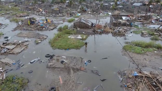
With over half the average June month of rainfall falling within 36 hours, parts of southern Trinidad remained underwater for a second night last evening.
The passage of a low-level trough and fast-moving tropical wave had brought multiple rounds of showers and thunderstorms to the country since early Sunday morning, with additional rainfall yesterday exacerbating flooding across the South Oropouche River Basin.
Across central and southern areas, rainfall totals ranged between 75 and 100 millimetres, with isolated totals exceeding 150 millimetres across southwestern regions—namely parts of Batchyia Village and surrounding areas based on automated weather station data. An average June produces 243.4 millimetres of rainfall at Piarco.
The Caparo, Guaracara, Couva, Arena, Cipero, Papourie, and South Oropouche Rivers overtopped their banks between Sunday and yesterday. While most river overflows from the had subsided by yesterday, the South Oropouche River overtopped at Pluck Road, Woodland; the SS Erin Road, Debe; and Boodoo Trace, Debe, yesterday.
Based on data from the Water Resources Agency yesterday evening, the Aripo River was at 35 per cent capacity; the Arouca River at 39 per cent capacity; the Caparo River was at 19 per cent capacity; and the North Oropouche River at Toco Road was at 37 per cent capacity.
The Caroni River at El Carmen was at 73 per cent capacity with a slight rise, while at Bamboo Settlement #3, it was at 64 per cent capacity. The South Oropouche River remained at 100 per cent capacity, overtopping in low-lying areas.
According to the Ministry of Rural Development and Local Government (MoRDLG), they received 96 reports of flooding spread across five municipalities—Couva/Tabaquite/Talparo (seven), Mayaro/Rio Claro (nine), Penal/Debe (59), Princes Town (14, and Siparia (seven). Authorities also responded to eight fallen trees, two in the Diego Martin region and six in the San Fernando area. There was one landslide in the Couva/Tabaquite/Talparo region, with two roof damage reports from the Couva/Tabaquite/Talparo and Mayaro/Rio Claro areas.
Municipal corporations distributed 780 sandbags across seven municipalities, six mattresses across two municipalities, eight tarpaulins across five municipalities, and one hamper in the Siparia Regional Corporation.
Riverine Flood Alert still in effect
After the second consecutive day of rainfall, the Trinidad and Tobago Meteorological Service (TTMS) extended the Riverine Flood Alert for South Trinidad until 5 pm today, upgrading the alert to Orange Level.
In their update on yesterday afternoon, they said, “After continued rainfall activity, the river levels of the South Oropouche, as well as smaller tributaries in Southern areas of Trinidad, are near critical levels or overtopping in some areas (based on official reports).”
The TTMS added that additional periods of rainfall will likely continue into today, which will result in further elevation of the river levels. They added, “Note that run-off will be slower at high tide, which will be at 12.04 am (Tue. 13th) and 02.03 pm (Tue 13th).”
Meanwhile, the Orange-Level Riverine Flood Alert encompassed mainly the South Oropouche River Basin, where the South Oropouche River and its many tributaries overtopped their banks yesterday.
Severe impacts are expected in the South Oropuche River Basin for an Orange-Level alert.
The public was advised to finalise preparations to protect lives, livelihoods and property, and activate their safety plan, secure food, water and medicine for at least seven days in waterproof containers, protect important assets and documents, and not take unnecessary risks. The Met Office also advised the public to follow the instructions of government officials, monitor official sources for information and secure loose outdoor items and livestock.
A consequence of climate change
With a warmer climate, although T&T has recorded lower overall rainfall in the Dry and Wet Seasons, extreme precipitation has increased.
Since 1985, the T&T Meteorological Service has recorded an increase in the number of extreme single-day rainfall events, extreme three-day rainfall, and an increase in the percentage of rain these extremely wet days contribute to our annual rainfall totals.


