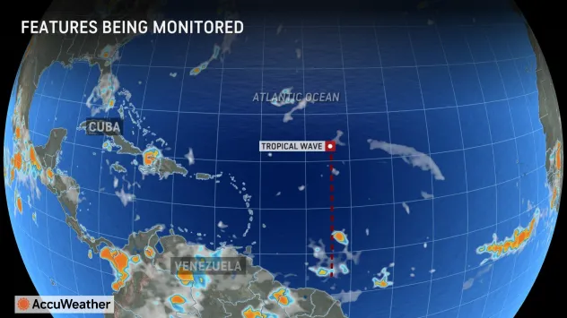
There are good reasons why people in the Caribbean and the United States should track the tropical rainstorm in the Atlantic.
Meteorologists are tracking a feature over the Atlantic Ocean that has a chance of evolving into a tropical storm before approaching the United States during early August.
The feature has some hurdles along the way, but conditions may become more favorable for development later on, especially as it nears Florida.
During the summer and autumn, low pressure areas known as tropical waves move from the Indian Ocean across Africa then the Atlantic. Of these, a small number go on to evolve into tropical depressions, tropical storms and hurricanes. August marks a time when the number of tropical waves that organize tends to increase substantially, as this is a time when water temperatures reach their maximum and restrictions from dry air, dust and winds tend to drop off.
Tracking a troublesome tropical wave
One particular tropical wave that caught AccuWeather meteorologists’ attention last week is a few hundred miles to the east of the easternmost islands of the Caribbean. The wave has a medium chance of developing.
“The tropical wave is currently battling a harsh environment in a sea of dry air as it moves west across the Atlantic,” AccuWeather Lead Hurricane Expert Alex DaSilva said. “The dry air is working to keep the wave from gaining any organization during this week.”
Wind shear, which is the effect of stiff, steady breezes in one direction or shifting directions, can inhibit tropical development or, in some cases, cause an established tropical storm to weaken.
Because the storm may be relatively dormant or poorly organized until it approaches Florida, people in the U.S. should not let their guard down.
“Around this weekend, the wave will move into an area with fairly low shear and ample moisture, and that could allow some organization and strengthening,” DaSilva added.
This feature will interact with another ripple in the atmosphere in the short term, causing the two to consolidate into one low-pressure area.
Exactly how these two interact and where they re-form as a single tropical rainstorm may determine the future path near the Caribbean this week and perhaps the U.S. beyond.
Proximity to large Caribbean islands may be a deterrent
“A major caveat is where the tropical rainstorm tracks,” DaSilva said, “If it tracks north [or south] of the Greater Antilles, then it will have a better chance to develop, as it will be removed from the towering mountains of Puerto Rico, Hispaniola and Cuba.” Large, high mountains disrupt the wind flow of a tropical feature and can inhibit its wind intensity.A tropical rainstorm that bounces westward, along the high mountains of the Greater Antilles, would likely struggle to organize. However, if the center stays away from the islands and their mountains, the waters are sufficiently warm to allow organization and strengthening.
Should the storm track near or north of the big islands of the northern Caribbean later this week, which is more likely, it would be a concern for the East Coast states, including Florida and the Carolinas. On the other hand, if the storm tracks just south of the big islands, which is less likely, it may be more of a concern for the U.S. Gulf Coast later on.
Contingent impacts on the Caribbean
If the storm passes close to or over the islands, a period of heavy rain, gusty thunderstorms and rough seas will progress westward over part of the northern Caribbean. Because of this concern, AccuWeather meteorologists are referring to the wave as a tropical rainstorm to raise public awareness and preparation. How intense conditions become will depend on the strength and track of the tropical rainstorm.
Heavy rain that triggers flash flooding and mudslides could be a concern, as well as high winds that might lead to damage and power outages. Building seas would create dangerous coastal conditions for boating and beach interests and possibly storm surge coastal flooding.
High pressure over central Atlantic to push tropical rainstorm along
Another player will be a large area of high pressure over the central Atlantic pushing the storm to the west, but only for so long. Later this weekend to next week, steering winds should turn the storm to the northwest or north near the U.S.
Because of these conditions, everyone from the northern Caribbean islands to the Bahamas and from the U.S. Gulf Coast to the Carolinas will have to watch this tropical feature closely.
By later this weekend to early next week, the storm could be turning northward along the U.S. Atlantic coast or perhaps be churning waters over the Gulf of Mexico, prior to moving onshore.
Assuming the tropical rainstorm has gained strength, even if it does not directly head toward a location along the U.S. Atlantic or Gulf coasts, seas and surf would build well in advance, resulting in a marked increase in the strength and frequency of rip currents, at the very least beginning this weekend along part of the Florida coast and either spreading northward along the Atlantic coast or farther to the west over the Gulf.
Should the feature roll ashore as a tropical storm or hurricane, impacts could be severe.
AccuWeather has not wavered from its prediction of a super-charged hurricane season for 2024 since this past winter.
Record-setting Category 5 Hurricane Beryl demonstrated the concern AccuWeather’s team of experts had about the potential energy available to extremely warm Atlantic waters.
As dry air diminishes and the effects of La Niña unfold late this summer and fall, great numbers of tropical storms and hurricanes are forecast, along with the likelihood of additional systems that rapidly intensify as Beryl did.


